The global Architecture, Engineering, and Construction (AEC) industry is undergoing a massive digital transformation. In fast-paced megaproject hubs like Dubai, Abu Dhabi, and Singapore, execution speed and structural precision are no longer just competitive advantages—they are absolute survival metrics.
As government bodies like Singapore’s Building and Construction Authority (BCA) and the UAE’s municipal authorities push for mandatory Building Information Modeling (BIM) workflows and Virtual Design and Construction (VDC) frameworks, a massive gap has emerged. While engineering offices design complex, millimeter-accurate 3D models, the actual physical construction site is still heavily reliant on traditional, manual verification methods.
This disconnect between the digital office and the physical concrete slab is where the majority of project delays and budget overruns occur. DeltaARBIM directly bridges this gap using advanced spatial computing and mobile Augmented Reality (AR) scanning. Here is how integrating DeltaARBIM into your construction workflows transforms field execution, protects profit margins, and accelerates your project timeline.
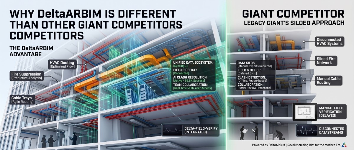
1. Eliminating the 21-Day Clash Delay Loop
In traditional AEC workflows, catching a structural deviation or a Mechanical, Electrical, and Plumbing (MEP) clash on-site triggers a highly inefficient, bureaucratic chain reaction.
When a field engineer notices that a cast concrete beam or a primary HVAC duct route does not align with the paper drawings, work stops. The engineer must raise a formal Request for Information (RFI). This RFI travels back to the design office, waits for a coordination meeting, gets updated in the master Revit or AutoCAD BIM model, and is finally re-issued back to the field. Industry data across Singapore and UAE megaprojects shows that this traditional loop takes an average of 21 working days to fully resolve.
DeltaARBIM completely compresses this bottleneck. By loading coordinated IFC models directly into a mobile AR pipeline via an iPad Pro, field teams can instantly cross-check physical execution against design intent. Instead of waiting weeks for office validation, site supervisors can identify, measure, and flag discrepancies right on the construction slab in 15 minutes. Work keeps moving, and the 21-day delay loop is permanently eliminated.
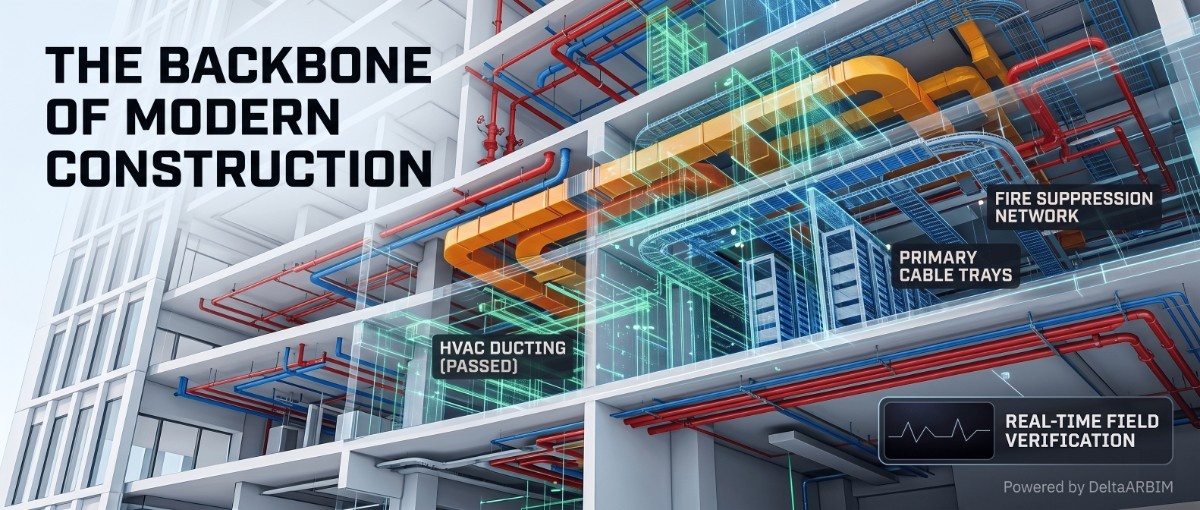
2. Achieving Absolute Precision with Edge-to-Edge AR Scanning
Modern smart city infrastructure leaves zero margin for error. Whether you are building complex commercial high-rises in Singapore's Downtown Core or high-tech manufacturing facilities and semiconductor fabs, structural alignment must be perfect.
DeltaARBIM introduces advanced edge-to-edge AR scanning specifically designed for heavy construction environments. Using mobile device tracking and LiDAR integration, the app snaps onto the physical edges, boundaries, and geometric corners of cast concrete slabs or structural elements.
The software dynamically calculates deviations between the built environment and the 3D BIM model in real time, validating tolerances to an accuracy level of $\pm$2cm. This allows site engineers to run automated edge-checking routines immediately after formwork is set or concrete is poured, catching minor misalignments before they harden into permanent, multi-million dollar mistakes.
3. Safeguarding Subterranean and Embedded MEP Infrastructure
One of the highest risks in infrastructure development is accidental utility damage. In master-planned industrial zones and smart cities, massive networks of high-voltage power lines, gas lines, automated waste chutes, and ICT fiber cables are pre-laid underground or embedded directly within massive concrete foundation slabs.
When heavy machinery breaks ground or secondary concrete pours begin, site teams are often working blind, relying on flat 2D schematic blueprints to guess where hidden services lie. A single accidental line cut can halt an entire district's development, incur massive regulatory fines, and destroy project profitability.
DeltaARBIM provides field teams with "through-wall" spatial visualization. By feeding coordinated utility and MEP layout data into the mobile AR application, field supervisors can literally look through the ground or physical concrete barriers using their device screen. Seeing hidden conduits and service trenches mapped out in 1:1 scale AR right over the dirt terrain completely de-risks excavation and drilling operations, protecting critical smart infrastructure from day one.
4. Maximizing Time-to-Market and Cutting Rework Costs
For international developers, institutional investors, and Project Management Consultants (PMCs), the ultimate financial metric is Time-to-Market. In commercial real estate and high-tech industrial sectors, a 30-day delay in commissioning a asset can wipe out millions in projected quarterly revenue and trigger heavy liquidated damages.
Statistically, unmanaged construction reworks account for up to 10% of a project's total budget. These costs stem directly from idle labor forces, scrapped materials, and the time required to tear down and rebuild faulty installations.
DeltaARBIM acts as a direct line of financial defense for project owners. By turning the coordinated 3D digital twin into an active, field-accessible reality, the software ensures that the project is built correctly the first time. The immediate financial benefits include:
-
Zero Material Waste: Catching an installation clash before steel is cut or concrete is poured prevents material scrapping.
-
Optimized Labor Productivity: Field teams spend less time waiting for design clarifications and more time executing verified tasks.
-
Protected Profit Margins: Eliminating structural reworks safeguards the contractor's bottom line and keeps the asset owner's timeline secure.
5. Ensuring 100% Digital Twin and LOD 500 Integrity
As smart facility management becomes the standard in regions like the UAE and Singapore, project handovers are shifting. Government authorities and private asset owners no longer accept messy, handwritten paper "as-built" drawings at the end of a build. They demand a certified LOD 500 (Level of Development) Digital Twin—a precise, data-rich digital replica that perfectly matches the physical building for long-term operations.
Traditionally, capturing as-built data requires deploying expensive, slow terrestrial laser scanners at the end of construction, only to find out that the physical building deviates significantly from the original design models.
DeltaARBIM ensures continuous digital twin integrity throughout the entire construction lifecycle. Because field verification happens incrementally on the slab during daily walks, the design model remains perfectly synced with physical reality. When the project reaches completion, the asset owner receives an authentic, field-verified LOD 500 model with complete spatial accuracy, paving the way for seamless smart building management.
Conclusion: The Future of VDC is Spatial
The future of construction belongs to companies that can merge digital intelligence with raw physical execution. Tools that keep data locked in an office computer are no longer sufficient for the speed of modern AEC megaprojects.
By putting the power of real-time mobile AR scanning, edge-checking, and subterranean utility mapping directly into the hands of field supervisors, DeltaARBIM fundamentally changes how buildings are verified and delivered. It replaces guesswork with spatial certainty, protects budgets from the drain of reworks, and ensures that the world's next generation of smart cities are built at maximum velocity.
Ready to Experience Millimeter-Level Precision on Your Site?
Don’t let manual measuring tapes and traditional 21-day coordination loops drain your project’s profit margins. Give your AEC team the ultimate technological edge and deliver your next build at maximum velocity.
Get Started with DeltaARBIM Today:
-
🌐 Explore Our Features: Visit our Demo Hub
-
📺 Watch the Tech in Action: View Live Site Scanning Video